
Here
are some of our ideas for prototypes we are planning to develop:
Peer-to-Peer
Urban Tapestries Network
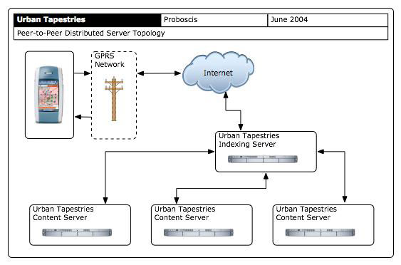
Our ultimate aim is to create a distributed server system for Urban Tapestries,
whereby people would be able to set up their own UT Content Servers (much
in the same way as webservers) from which they could store and serve their
own content.
To enable the sharing of the accumulated knowledge of so many different servers, Proboscis would develop an indexing system. Client devices would send location requests to a UT Index Server which would pass the client device's request on to those servers with threads and pockets that are within a certain radius of the coordinates. Individual servers would interpret the permissions and preferences of the client device and return matching information.
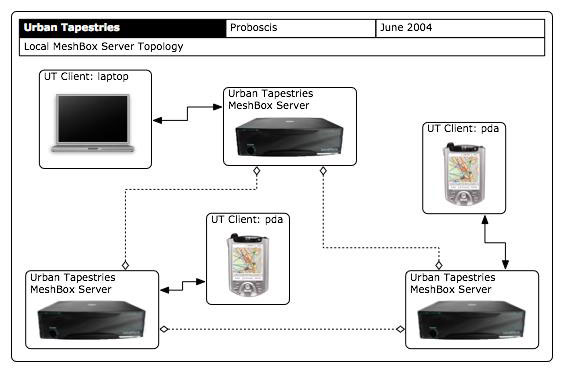
Urban
Tapestries MeshBox Servers
Another possibility for extremely local UT servers is to embed them within
WiFi base stations, such as Locustworld's MeshBoxes. The client –
perhaps a laptop or PDA, or even a bluetooth enabled mobile phone –
would use a simple browser to log onto the wireless connection and be
served local maps and information relating to the local area in which
the meshbox is situated.
Hybrid
& Lo-Tech Location Positioning
Whilst the drive to embed automatic location-positioning in devices continues,
Proboscis is interested in more heterogeneous modes of determining location
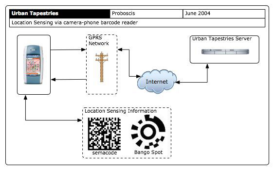
that combine creative uses of existing technologies. From software bar-code
readers for camera-phones to RFID tags and readers, to Bluetooth beacons
and increasingly sophisticated WiFi spotters, there are a wealth of possibilities
for simple, cheap and effective location markers to be embedded in the
fabric of our towns and cities that will enable mobile and wireless devices
to determine their position without needing to rely on satellite positioning
systems such as GPS, Glonass or Gallileo. Combined with our existing indicators
for location positioning (such street signage, building names and numbers)
the following ideas offer a multiplicity of options, and avoid th dead-end
of a single one-size-fits-all solution.
Almost all of the techniques and technologies suggested below do not rely on users being tracked or on giving their position to third parties, thus each has significant advantages in terms of privacy issues.
For
instance, instead of a URL, a semacode
or a bango
spot could contain longitude/latitude coordinates (or postcodes or
even a street address). With a simple script on a webpage to create the
image anyone (such as local shopkeepers) could print off a location code
and paste it up in their window. People with the relevant reader on their
camera-phone could then capture the location just by pointing and clicking.
Given the increasing interest in collaborative cartography and location
positioning it is not hard to imagine scenarios where people might deliberately
capture the log/lat coordinates of architectural features such as street
furniture (phone boxes, post boxes, benches, bus stops etc) and attach
such location codes as stickers. Cheap, easy and with great potential
for social benefit.
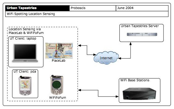
Other
simple location determining solutions could also be used, such as Placelab
or WiFiFoFum.
These take advantage of the existing properties and capabilities of WiFi
and Bluetooth radio technologies for location sensing. As location databases
of WiFi base stations are created and maintained by local users and enthusiasts,
it becomes possible to use the existing and ad hoc infrastructures that
make up our everyday environment for additional creative misuse.
Looking farther ahead, it may eventually become cost-effective for near field radio technologies such as RFID and Bluetooth beacons to be used for similar purposes – perhaps broadcasting the longitude/latitude coordinates, postcode or street address of a particular location. However it is likely to be some time before simple programmable versions of these technologies reach the hands of ordinary people and the relevant hardware is incorporated into everyday devices.
Complex
Relationships to Space & Place And with automatic location sensing it would be possible to set event triggers to play content as one enters a zone. Having such control over the granularity of our spatial annotations would make this an extremely powerful tool, and allow for the broadest range of interpretations of what constitutes a 'place' to its users. |
 |