
Urban
Tapestries: an experiment in location-based wireless co-creativity
(working title)
Katrina
Jungnickel, Giles Lane, Rachel Murphy & Nick West
Urban Tapestries is a framework for investigating social and cultural implications of pervasive location based wireless environments. It is designed to encourage people to embed social knowledge into the fabric of the city via wireless and mobile networks, using a variety of geographic information systems to link memories, stories, histories, images, sounds and movies to specific places. It provides an electronic forum for people to capture and recall their experiences and share them with others.
To demonstrate our ideas, Proboscis is developing an experimental interactive location-based wireless application for wireless and mobile devices. Designed to be a collaborative and co-creative tool, Urban Tapestries itself is being developed by a transdisciplinary team comprising designers, artists, sociologists and technologists. Led by Proboscis, the project is a partnership with the London School of Economics, Hewlett-Packard Research Laboratories, Orange and Ordnance Survey, with assistance from Locustworld and Birkbeck College. The project is funded by the Department of Trade and Industry, Arts Council England and the Daniel Langlois Foundation for Art, Science and Technology.
The following three sections discuss and explore content gathering tools and social knowledge, technology now and the prototype in development and applications of future technology.
To imagine a community organically recording layers of histories, experiences and events that are linked to familiar locations and accessible to everyone sets the context for Urban Tapestries – a forum for exploring and sharing experience and knowledge, for leaving and annotating ephemeral traces of peoples’ presence in the geography of the city.
Urban Tapestries allows users to author their own virtual annotations of the city, enabling a community’s collective memory to grow organically, allowing ordinary citizens to embed social knowledge in the new wireless landscape of the city. Users will be able to add new locations, location content and the ‘threads’ which link individual locations to local contexts, which are accessed via handheld user devices such as PDAs and mobile phones.
Traditionally knowledge is viewed as the preserve of experts – locked up in books and universities, created by and defined as the property of individuals or entities. Changes in value systems and perception of what constitutes knowledge have broadened and extended our understandings of what knowledge can be, where it resides and how it is created. Increasingly we are coming to value the kinds of knowledge bound up in the practice of everyday life, what we are typifying as 'social knowledge'.
Social knowledge can be understood as a form of social capital – something that has intrinsic value within a context of locality and community, if not a clear relation to monetary value. The more deeply embedded within a context such knowledge is, the harder it is to gauge its value – what systems like Urban Tapestries offer is a means to expose this knowledge and the social networks that support it, widening access and understanding of crucial resources.
Social knowledge can be interpreted as encompassing both ideas and memories as well as behaviours. It is a term that attempts to indicate the broad variety of human activities, concepts and ways of being social: from how we interact with shopkeepers and follow routines of travelling through the city, to how we take part (or not) in communal activities. It could be described as the hidden or obscured resources and assets of a locale or of a community – created between and around people as they go about their daily life.
As part of the research into Urban Tapestries, we are working with potential users to try to imagine as many different uses as possible. Since the city is often described as canvas for its inhabitants to express themselves on and through, we are trying to devise a model that does not limit the creativity of its users.
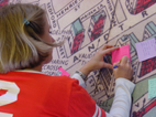
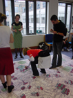
In order to explore how people of different ages and social, cultural and economic backgrounds engage with the system we designed a Bodystorming Experience. Bodystorming is similar to brainstorming except it involves physical interaction and engagement with the system through a playful acting out of the issues, techniques, interface and interaction possibilities that Urban Tapestries seeks to engage with. It is also an ideal content gathering tool. The experience was first tested at the Creative Lab in May 2003, and has been used for research, user testing and as a presentation and performance tool.
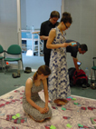
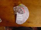
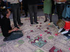
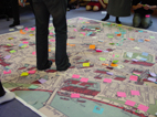
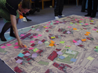
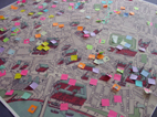
The experience encompasses a number of tools; a large map of the Bloomsbury area, which can be walked upon, a laminated mock-up of a device such as a mobile phone or PDA, stickers, post-it notes and pens. The concept requires participants to walk through the area noting coloured dots and threads on the map and reading content linked to their mock-up device. They then author their own content using Post-it notes and stickers and locate them in specific areas on the map. The individual items of content are linked via a title or theme, which creates a thread to follow through the city. At the end of an hour session participants are invited to walk through their thread and share their experience with the group.
We have run many iterations of the Bodystorming Experience, using wall mounted, table and floor maps and different types of mock-up devices. Each one is specifically designed for the audience involved. We have worked with groups of artists, academics, civil society workers, technologists, business people and local community groups. The most recent event was held at the Marchmont Community Centre in Bloomsbury. We were invited to work with a combined Arts & Culture and Intergenerational group. Each member was either over 70 years of age, and intimately involved in the area having lived most of their lives or raised their families in Bloomsbury, or under 16 years old.
Both groups greatly enjoyed the experience and we have been invited to return to run the event again. Specifically they enjoyed the ways in which Urban Tapestries encouraged cross-generational story telling and information sharing. One woman shared a story about her wedding at Camden Town Hall over 60 years ago which sparked a conversation with a young Bangladeshi girl whose sister had been married in the same place a week before.
These kinds of stories excavate locations to reveal connections between people, time and places. Camden Town Hall became a catalyst for other conversations about families and what it was like to get married at different times. A connection was made between two generations of women through a location, previously unlinked to each other. These are the serendipitous connections of social knowledge that Urban Tapestries is designed to reveal.
Each Bodystorming Experience is different providing an eclectic, rich and textural perspective on the area. From open public threads entitled ‘Hidden safe cycle paths in London’ and the useful ‘What to do when you have guests in London’ to more poignant ‘Places my father used to take me’ and personal ‘Secret sounds of London’. Whether the threads are fictional or fact, personal or a shared experience, each one provides a valuable and unique contribution to our understanding of the city.
The Urban Tapestries model is intended to be accretive and organic rather than static, mimicking the ways in which knowledge is built up in communities and in society in general, a real-time microcosm of how our cities grow, thrive and die. It is intended to grow with time, at a pace set by its users, and to function as both a layering and excavation of the richness of experience and knowledge accumulated by its users. In this way Urban Tapestries provides a powerful alternative to the single authored storytelling in our museums, history books and media. By collecting these stories a community’s memory grows on many levels with a hierarchy defined only by a user accessing what is of interest to them.
Many attempts
at designing wireless location-based services have focused on providing
tourist information or re-purposed material drawn from existing print
and broadcast media. Real city life is richer and more complex than this,
relying as much on social networks, personal experiences and chance interactions
and connections. We believe that pervasive wireless/mobile platforms should
attempt to reflect this richness and complexity, rather than re-purposing
solutions designed for a different age. The peer to peer and multiple
points of connections offered by internet-based networks present wholly
new ways of inhabiting the city and communicating with the people around
us in everyday situations.
The Urban Tapestries model relies fundamentally on communities, not on
service or network providers. It is intended to be a pervasive rather
than ubiquitous service, rooted in locale and community. A local Urban
Tapestry could be as small as a street, or as big as a district. It proposes
that the kinds of information about the city that we need on an everyday
basis are far more likely to come from our neighbours and colleagues than
from large corporations or the media.
The goal of Urban Tapestries is to discover if annotation and story-sharing can become an integral part of urban living. With this over-arching research mandate in mind, we developed a series of design requirements for how people should experience our project:
- people should be able to access information via devices that are generally familiar to them, i.e. PDAs or mobile phones;
- people should be able to access information in a variety of media (meaning text, still pictures, and, where possible, audio and video);
- people should be able to access information whilst walking down urban streets (that is, not indoors connected to a computer, and not standing at a particular outdoors location like a kiosk);
- people should be able to access information about the specific street address where they are standing, i.e., “right here” instead of the block or the neighbourhood;
(For all of these design requirements, it’s important to keep the
range of the project in mind: we aim to reasonably predict what might
occur within a 2- to 7-year time frame. This allows us to use off-the-shelf
hardware and software solutions in our prototype, and grounds our thinking
in the extrapolation of current trends. For more long-term speculation
of where these tendencies might lead, see the subsequent section on Future
Technologies.)
We have translated the above design requirements into a series of specifications for the hardware and software of our prototype. The following sections examine our proposed solutions for each of these specifications.
ACCESSING
INFORMATION ON FAMILIAR DEVICES
Currently, both mobile phones and personal digital assistants (PDAs) are
widely used by urban dwellers. We are building a client application that
will run on a recent release of each of these platforms that is able to
run Java. While it may be impractical to construct client software that
will run on every conceivable mobile phone or PDA, it seems a
reasonable goal to aim at the market of Java-enabled devices.
By building our client for currently-existing devices rather than any experimental units that we might construct, we gain access to a wide population of users that are already familiar with the basic operation of these devices.
ACCESSING
INFORMATION IN DIFFERENT MEDIA
Most cities are dotted with historical plaques and other fragmentary signage
that gives disconnected information – usually wayfinding or commercial
in nature – about the city. For Urban Tapestries, we want to make
available as full a range of media as possible: not only text, but pictures;
and sound and video if it’s technically feasible.
To enable
such multimedia displays, we need three separate capabilities: capture,
transmission, and display. Fortunately, multimedia capture devices are
widely available and portable. Digital cameras, recorders, and camcorders
are widely owned by the same general population that uses mobile phones
and PDAs. For the purposes of our prototype, we are assuming that users
will create multimedia content on their own using these devices.
Multimedia transmission will depend on the available bandwidth to our
target devices, which we discuss more fully below.
Multimedia display will be through means of standard HTML augmented by
Flash. So as long as our target devices can operate a current version
of an internet browser, the multimedia information for Urban Tapestries
can be easily displayed.
ACCESSING
INFORMATION WHILST WALKING
Mobile phones have been the first widespread example of a technology that
we can access no matter where we are standing in the city. The challenge
is to expand this experience to the other forms of media required for
the ideal operation of the Urban Tapestries prototype: still pictures,
audio and video.
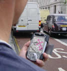
This requires not only sufficient bandwidth, but sufficient coverage in our target neighbourhood of Bloomsbury. Mobile phone networks now use the GPRS standard for their current 2.5G networks, which provides a sufficient bandwidth to display still pictures, and possibly a limited version of streaming audio and video. We plan on testing Urban Tapestries on a current 2.5G phone using GPRS to evaluate this capability. Though widespread in its coverage – essentially the same as mobile phone coverage – GPRS does have the drawbacks of both a per-unit charge and a relatively slow speed of 19.2Kbs at best. The advent of wireless LANs (or Wi-Fi) has offered another option with perhaps greater available bandwidth: depending on distance from the access point, Wi-Fi can offer up to 200Kbs. At this bandwidth, streaming audio and video become much more feasible.
Although its use is growing quickly, there are tradeoffs in using Wi-Fi. For one, its range is limited: a normal access point has a range of only 100 metres or so; this can be cut dramatically by intervening buildings or foliage. Another tradeoff is security, as wireless networks are inherently more accessible to the public and can be hard to secure.
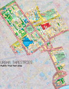
To help mitigate both of these concerns, we have chosen to use the LocustWorld MeshAP access points to set up our wireless network in a section of Bloomsbury and a few adjacent streets (see map). These access points set up a mesh network amongst themselves, which extends the range beyond that possible with completely separate access points. As well, access to the network will be by means of virtual private network (VPN), which will increase security of the network.
ACCESSING
INFORMATION ON A PARTICULAR STREET ADDRESS
As outlined above, most of the stories that we generate about our lives
in the cities revolve around our trips between and by different points
in the cities. Almost always, these points are defined – by both
ourselves and our listeners – as their associated street addresses.
Accordingly, any system of annotating the city should provide access to
information keyed to specific individual street addresses.
Although
there is some variation due to the varying width of buildings, a resolution
of between 5 to 10 metres should be sufficient to pinpoint a location
in the city as being at a particular street address. Most location technology
cannot yet deliver this resolution, but there are some hopeful developments
on the horizon.
The most widespread form of location technology is based on the Global
Positioning Satellite (GPS) system. By receiving signals from this constellation
of 24 satellites, current receivers can deliver location information within
20 metres in open country, and somewhat less in the city, where foliage
and buildings can interfere with the ability to receive signals from the
satellites.
A relatively new series of systems, generically called WADGPS (Wide Area Distributed GPS), are providing terrestrial-based error correction signals that can bring resolution to 5 metres in open country – which is the range of resolution that we need in order to deliver accuracy that is generally correct to one street address. In North America, the WAAS system has been in use for some time, and the EGNOS system is currently being tested in Europe and is slated to be permanently available early in 2004. Unfortunately, these additional error-correction signals are still hampered by the ability to fix on available satellites from within the city. We will be conducting tests within our Bloomsbury target neighbourhood to determine what the average resolution of these systems actually is.
Some hope for the future improvement of GPS signals lies in the development of various amplification schemes that increase the apparent strength of the GPS signal, thus providing the 5-metre resolution that is available under ideal conditions. For the present, however, we need some method of approximation for Urban Tapestries that will allow us to deliver information about particular street addresses. On the hardware side, we are continuing to investigate alternative distributed GPS add-ons that might deliver the desired resolution. But we have also decided to offer a hybrid solution that can definitively deliver the desired resolution. To provide an Ordnance Survey map of the general area that a user is standing in, we will use a GPS/EGNOS receiver to fix a position within 30 metres of the user, and have the server deliver a map screen that is centred on that spot. The users themselves will then indicate by clicking on the map exactly which street address they wish to interact with (either for viewing or authoring). Since can most often determine this information from signage on the street, we leverage our technological solution with the knowledge that the users bring to the situation. (And for those situations where the street address can’t be determined on the spot, it will be possible to either browse through the available options (for viewing), or modify the specific fix-to point (for authoring.)
Currently within the Urban Tapestries project we are using off the shelf technology to test a working prototype of the Urban Tapestries system. In the following section we explore different ways in which users of Urban Tapestries can view, interact and author digital content using other types of technology and interfaces. Not only do we explore the types of technologies people may use with Urban Tapestries but we also look at the different types of information that people will be viewing and authoring. We believe that data will often be accessed and authored on the types of appliances it to be created by.
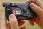
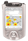
As a fundamental part of the Urban Tapestries system we feel it is important for people to know where they are in a physical space. In response to this need we decided to provide a dynamic map of the area on the screen of any device used to access Urban Tapestries. In some of the following ideas and figures you will see the use of maps for this very purpose
We believe that Urban Tapestries will be a rich source of data that may form patterns about the way the system is being used. For example some geographic areas may be more popular in terms of authors leaving content than others. As an indication of our interests we have created a visualisation that shows one method for how this information may be displayed. For example a user could see a graphical layer super-imposed on top of the map provided representing popular places to leave messages.
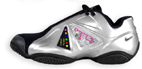
We feel that Urban Tapestries will be accessed by smart appliances other than Personal Digital Assistants (PDA) and (smart) phones currently being used. The following ideas explore the use of a smart wirelessly connected digital camera that would be used to access various types of overview data. This interface would allow amateur photographers to view statistics on the digital camera screen about the type and amount of photography that has been done in a given area. Below, the use of bar charts represents popular places to take photos:
Some people have problems deciding on the best way to take a photo. Another
instantiation of these digital cameras would be the ‘Good Photo’
function. A user would be able to select an option that would alert them
when they past through a place that is a good photo opportunity. Not only
would the user be able to access other peoples good photos but they could
also leave their own by taking a photo and uploading it to that location
with perhaps a few pointers and tips on times of day and specific angles
to point the camera in:
Along the same lines a user with one of these cameras would be able to
leave a photo thread. These threads would be linked to certain subject
areas such i.e. “nice places to take pictures of the river”
and could be viewed as routes superimposed on the digital camera screen:
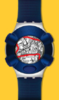
Following on along the imaging theme is ‘Electronic Geoglyphs’ which like the geoglyphs at Nazca in Peru, ‘E-Geoglyphs’ are similar apart from the fact that they exists in the digital world. These geoglyphs could be created by smart footwear that would leave a coloured electronic trail wherever the artist has walked. These images could then be accessed by geoglyph enthusiasts on a viewing device:
The smart footwear could also be used by fitness fanatics to create good jogging routes, by laying down subject specific digital trails. Other joggers would be able to access these routes via a map interface on a wirelessly connected watch:
With
routes in mind, remember the Games Workshop books that you had to roll
a dice to help you to decide what chapter to read next. Imagine a device
and service that allows the reader/listener to dictate the direction of
a story they are listening to by walking a different route through the
city.
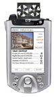
As a method for leaving these stories a blow device would allow the author
to release their finished content into the digital realm by blowing into
the fan attachment at the top of their device:
Another instantiation of the storytelling device would be an MP3 Player with wireless connectivity to 802.11 and GPS. As the listener moved around the streets of Bloomsbury they would be able to tap into tunes made by music artists that would mix seamlessly into one another as the listener chooses where to walk. So for example one tune may be linked to one street and depending on the direction that the listener then decides to walk would depend on what kind of tune they would listen to next, hence creating a location based music mixing method. This idea would be a perfect use for the automated DJ system being developed by Hewlett Packard Research Labs.
Authors who
captured information on the move and want to see it on a larger screen
could use PCs in cafes, bars and libraries to view and organise their
information. The author/viewer would be able to capture information on
move and then download it onto these screens using technology such as
Bluetooth. An even further variation on the use of other screens to view
and author content would be large organic LED public displays at places
like bus shelters and in town centres that would allow multiple users
to organise, create and view content.
By writing and publishing these ideas we have a method for documenting
the projects process for the future of Urban Tapestries and we hope that
they will be used to influence the thinking on similar projects around
the world.