As a platform and framework Urban Tapestries prototype is intended to be network and device agnostic, i.e. not a product or service designed for a specific brand, technology or service. Ideally it should be able to run on a number of different types of mobile pervasive device (PDAs, smartphones, tablets etc) and to connect to the internet across different networks (GSM, GPRS, UMTS/3G, 802.11x etc). For the public trial we have narrowed the devices down to two: the SonyEricsson P800 and the HP iPAQ 5450, connecting via GPRS and 802.11b respectively.
USER
DEVICE
The Urban Tapestries prototype is anticipated to use several different
user devices running a Java client application as the browsing and authoring
interface to the system. Devices currently being researched include
Pocket PC/Windows Mobile, Symbian and PalmOS devices. For the pubic
trial we hope to have several different devices with combinations of
Bluetooth, 802.11b WiFi, GPRS (General Packet Radio Service) and GPS
(Global Positioning System). The system will be scalable for a range
of different devices since not all features will be accessible to every
type of device.
PUBLIC TRIAL: SonyEricsson P800s running native c++ client over GPRS,
and, HP iPAQ 5450s running a FLASH client over 802.11b.
USER
INTERFACE
The interface for the client device is likely to have simple and expert
modes for people to choose how they wish to use the system. Filtering
the content will be done on several levels; users will create Profiles
to store different sets of filter preferences that they can switch between;
filtering preferences will allow users receive by file type (for exapmple
only audio or text files), keywords, author, time etc. Filters will
work both as 'exclusions' prohibiting content and as 'inclusions' accepting
only specified content.
PUBLIC TRIAL: Interface will focus on authoring mode, with no filters
or profiles enabled due to limited duration of each session (2 hours).
LOCATION
SENSING
Several location sensing technologies are being investigated, including
versions of GPS (Global Positioning System), mobile phone cell triangulation,
802.11 node proximity and direct user input (via a visual map, post
code, street address, GPS waypoint etc). Location awareness is a sensitive
privacy consideration for users with a trade off between fears of government
or corporate surveillance and access to location specific information.
We currently plan to build in two options to UT: Automatic Location
Sensing, where the user allows their device to send their position automatically
to the UT system to provide instant access to local content and, Manual
Location Input, where the user uploads their position directly to the
UT system in order to receive local content as and when they choose.
PUBLIC TRIAL: Manual Location Input, or User Declared Location will
be the system adopted for the trial.
INTERNET
CONNECTION
The user device will communicate with the Urban Tapestries system either
through its 802.11 WiFi card or via GPRS or UMTS/3G (such as through
a Bluetooth connection to a GPRS or 3G mobile phone). Density restrictions
with 802.11 use of the radio spectrum and the current lack of interoperability
between WiFi nodes are suggesting that a Mesh/Ad Hoc 802.11 network
which enables peering between users will be the most appropriate WiFi
solution for the alpha prototype trial.
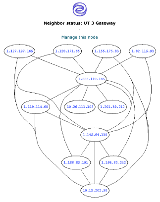
PUBLIC TRIAL: Proboscis is setting up its own 802.11b Mesh in Bloomsbury
using Locustworld's MeshAP for the iPAQ 5450s to connect to. SonyEricsson
P800s will connect via the Orange GPRS network.
SERVER
ARCHITECTURE
Urban Tapestries will being designed using a server-based component
architecture (but not an open API model) responding to data requests
from the user device. The server will contain a content database, media
files, a location interpreter application, a dynamic map drawing application
as well as the main application server handling requests from the client
device (XMLRPC) for location specific UT content.
PUBLIC TRIAL: The system architecture has been designed to be scalable
to requirements, serving and publishing authored location-based content
to and from users, resolving location requests via its GIS map server,
and registering users onto the system.
 |
sample
mesh node map |
